Apparently so - we are here for the last 3 days of this trip! As noted at the Smithsonian - "In the quest to identify the roots of Rock 'n' Roll, all roads lead to Memphis."
Our previous stop was Ozark, AR and we were still about 440 miles from home. We try and limit an RV moving day to around 300 miles, so we decided to make an easy travel day with a return trip to Memphis. We spent 18 days here back in 2008 when we were traveling 1134 miles by boat to Muskogee, OK via the Tennessee, Ohio, Mississippi, and Arkansas Rivers. The Mississippi River was in flood stage which was okay since we were traveling downstream, but we needed to go upstream on the Arkansas River for 400 miles to Muskogee and the Arkansas was in flood stage also. When the river is running 5 mph and your trawler is only doing 9 mph - well, you do the math. Plus, the Arkansas River is a little dangerous in those conditions. Memphis is the last marina stop southbound on the Mississippi before the Arkansas, so we delayed there.
We spent that time at Mud Island Marina, below. We stopped in at the marina office to inquire about some of the nice folks we met there and of those we named, all had moved away. By the way, that's Bass Pro Shop's pyramid location in the distance, more on that later.

The big attraction at Mud Island is the riverwalk. It's a nicely done, 1/2 mile walk, depicting the watershed area and detailed topography of the lower Mississippi River. Water actually flows from the watershed areas displayed through the topographical depictions of the river with larger towns depicted along the way also. Here's a view of a small section of the general design from 5 stories up.

And a closeup of the detail. The town depicted here is Memphis with the interstates, railroad bridges, and Mud Island. We have traveled the Mississippi River by boat from St. Louis to New Orleans (except for a short distance from Baton Rouge to New Orleans when we detoured over to the Atchafalaya River) and we enjoyed remembering our stops at numerous cities along the way, most all of which are depicted in the Mud Island display.

A view of Memphis from the New Orleans portion of the Mississippi River display at Mud Island.

Rhonda also likes the view of the I-40 bridge from Mud Island.

We also spent an afternoon on Beale Street.


I expect most of you have been there, but it is about a 6-block area of shops, bars, restaurants, music, and lots of people, with some restrictions in the cordoned off areas. You'll notice the top two are violated in the picture.


Many blues and rock 'n' roll musicians are memorialized in the sidewalks of Beale Street. Here's one you probably recognize.


We caught two excellent bands that afternoon playing in public outdoor venues. "Three Pieces of Chicken, a Fluffy Biscuit, and a Cup of Sweet Tea" (long name for a band) was our favorite with some serious local talent. They were playing in the W.C. Handy Park, working for tips and sales of CDs. They did a check of where the audience was from - AL, ME, OH, FL, TN, KY, and Australia to name a few.


There are many interesting and unique (translated "odd") things to see as well. Goats on circular stairways being fed by customers, and specialty toilet seats to name a couple.


We enjoyed the music, the crowds, the atmosphere, and had an outstanding meal at Central BBQ, recommended by my good friend, Ross Tilbury. Ross and his wife, Polly, were friends of ours in Shreveport, LA right after we got married. After we left Shreveport for Savannah, GA we lost touch over the years. They moved away also and had their own BBQ restaurant in Boise, ID for many years. Ross is a big fan of blues and rock 'n' roll music also and tied that into their logo for their restaurant, "Roadhouse BBQ."

They have retired and moved back to Shreveport. We have reunited with Ross and Polly a couple of times recently and Ross is now a certified, documented, approved (or whatever you call them) judge for BBQ competitions. Good recommendation at Central BBQ!
Back to the Bass Pro Shops pyramid. It was originally conceived as a symbol for the city of Memphis on the bluffs of the Mississippi River. An assortment of possibilities for its use were considered. The groundbreaking was in 1989 and the building opened in 1991. It eventually became a sports arena for the University of Memphis men's basketball program, the NBA Memphis Grizzlies, and the Memphis Pharoahs of the AFL, as well as a venue for an assortment of special events. It later became insufficient as a sports arena, and as teams moved to the newly constructed FedEx Forum in 2004, other possibilities had to be considered. Bass Pro Shops opened there in 2015 as a specialty retail complex.
This thing is pretty amazing and is one of the most dynamic and intriguing retail facilities we have ever visited. It has 3 levels inside housing a hotel, duck heritage center, restaurant, 28-story elevator right in the center to a top-of-the-pyramid viewing area, a bowling alley, archery center, fish ponds and aquariums, and of course the normal retail displays.

You should google it to get the full picture. Ours do not do it justice but for what it's worth.....


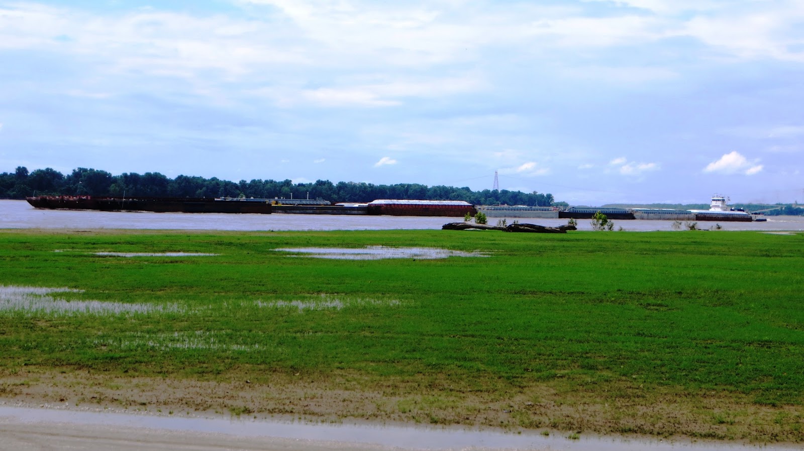
Our RV Park at Memphis is an interesting story as well. You have to wonder about the logic (or lack thereof) in locating an RV Park inside the levees of the Mississippi River basin, not very high above normal pool stage for the river! Obviously, you run the risk of flooding. The Tom Sawyer RV Park had been under water for about 2 months and had just reopened in the last couple of days when we called for a reservation. Here's the crest recorded from a flood in 2011.

But when it's not under water and covered in river mud, it's a beautiful setting right on the river with constant barge activity. Here's one of the larger tows - 7 barges long and 4 wide. The largest we ever saw while boating the Mississippi was 7 long and 6 wide. In short, you need to stay out of their way! It's imperative that you communicate by radio with the towboat captains so they can let you know where they need you to position your boat to accomplish that goal.
Here's "Tom Sawyer" stuff for the park theme.


So, we had fun with our return visit to Memphis.
We also thought it appropriate to visit Miss Cordelia's grocery store and deli down the street from Mud Island. When we began our boat trip to Muskogee, we wanted a way to keep our friends, family, other boaters, and anyone else interested, aware of our travels. Remember, that was 2008 and I could barely spell "computer" much less knew what to do with one. So, our older son, Adam, said "you need a blog" and set one up for us. Again, in 2008, WIFI was hard to find and we certainly did not have our own Hot Spot, not sure if they even existed. Anyhow, we found good food, groceries, and WIFI at Miss Cordelia's and spent hours there at this table getting the blog up and running with Adam's supervision.


We checked and the public WIFI is still up and running.

And, as of this posting, there have been 110,752 page views in 10 countries since we began the blog at Miss Cordelia's in 2008! We appreciate all who have traveled along with us and we hope we have provided some interesting and helpful information. We hope to be back on the road again after a couple of weeks, heading north and then west for the summer. See you then.