We left Williams, AZ and headed back into Utah. We visited northern Utah about a month ago at Salt Lake City, then crossed into Nevada after the Bonneville Salt Flats. Most of the beautiful scenery though is in the southern half of the state with numerous national and state parks - Zion, Bryce Canyon, Canyonland, Glen Canyon, Escalante/Grand Staircase, Capitol Reef, and Arches. I guess it's certainly possible to visit all of these, but we just don't have the time on this trip. So, we'll show you some scenery from Williams, AZ to Blanding, UT, a trip to Arches, and my 610-mile, 2-day motorcycle ride from Blanding to Panguitch which crosses Glen Canyon, Escalante, and Bryce Canyon.
The variety of terrain still amazes us. There is literally a new and different photo shot every mile and around every new corner and curve.
Three stone space aliens.
Remember our first "Devils Tower" in Wyoming? Utah has towers that are even taller in some places.
This spot is known as "Mexican Hat." Note also the beautiful backdrop.
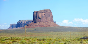
And this is quite an iconic shot in "Monument Valley." Lots of movies and shows have included this area as a symbol of the American west - Back To The Future III, National Lampoon's Vacation, How The West Was Won, and The Lone Ranger to name a few. One of the most notable is "Forest Gump" - the location where Forest stopped running. "I'm pretty tired, I think I'll go home now."
And you see some interesting "other" things along the way. We have never seen a building on top of several silos before this trip.
This jeep looks to be in a slightly precarious position. Look closely on top of the rock toward the left side! Not sure if that is a promo for "Hole In The Rock" or an adventurous driver.
And I want to point out a wonderful thing about an RV. When you are literally in the middle of nowhere, you can pull over and enjoy the conveniences of home. Well, if you can find a place to pull over of course.
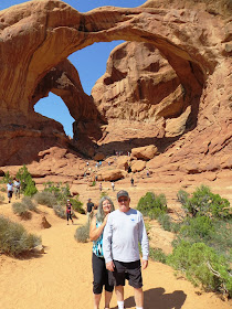
The main focus at "Arches" is uh, the "Arches." We checked out 4 of them. This first one is a "double arch."
Others.
And I had one of my best motorcycle rides of the trip - 610 miles. It is rated as the #1 ride in Utah and is 300 miles long one way. That's about my limit for one day and calls for an overnight stop to rest. I rode it pretty much non-stop the first time through, except for fuel and food, just to enjoy the ride. The route started at Blanding and includes Glen Canyon, Escalante/Grand Staircase, and skirts the edge of Bryce Canyon. My overnight was at the KOA in Panguitch. I don't need much after a long day and when you rent one of their cabins you don't get much - a bed, folding metal chair, a light, and a space heater. I really appreciated the space heater - it was 37 degrees that night and I had frost on my bike the next morning. You also have to provide your own pillow, linens, and towels. No water or bathroom, but they had recently installed new and private bathrooms and showers only about 50 steps from my place.
In 300 miles, the scenery changes a lot as we have frequently noted. Leaving Panquitch, you cross an area called Red Canyon with a couple of arches over the roadway. You can see the second one just down the road looking through the first one.
Then you go through Bryce Canyon City and catch a little of Bryce Canyon from the highway.
It's a little more spectacular inside the park, but I did not have time for that plus it involes a lot of hiking to see the best in Bryce. (Picture from Yahoo images)
Then you get into the hills and curves of Escalante.
You better be paying attention running the crest of the hills between 2 canyons. The road is narrow with steep drops on both sides AND NO GUARD RAILS!
Then you begin the descent into a huge area of "not what you expect to see in southern Utah" - green hills. You can see them in the distance.
With a few aspens to boot, the elevation at the summit in this area is 9,600 feet.
You make the turn at halfway in the town of Torrey and immediately enter just the opposite - rock and more rock.
Glen Canyon is next with miles and miles of red rock and lots of curves, heading for the Colorado River gorge and the headwaters of Lake Powell.
Lake Powell at Hite, UT. If you look closely, you can see the concrete Hite boat ramp a long way from the water which is really low right now.
Just upstream from the above shot is the bridge over the Colorado River.
Upstream.
Downstream.
Leaving Glen Canyon, you enter about 75 miles of beautiful ridge and plateau on one side of the road and canyon on the other.
Approaching Blanding on the east end of the ride, there is a huge pass in the hills where they cut the road through. (V on the right side of picture.)
Nice view from inside the cut.
It was a fun ride and one of the most scenic of this trip. Still behind on the blog. We left Durango, CO this morning and are currently in Alamosa, CO. The Colorado weather is starting to close in on us. 25 to 30 mph winds gusting to 40, rain, snow forecast in the higher elevations we just left around Durango, and nighttime temps in the 30s, headed to the 20s. Hope we make it out in time!


No comments:
Post a Comment