Tuesday, May 14, 2013

Corinthian Yacht Club to Solomons, MD

We left our anchorage at St. Marys with a short 15-mile run to the Corinthian Yacht Club (CYC) in Ridge, MD, close to the mouth of the Potomac River.  CYC is celebrating its 110th anniversary and offered a special for Loopers traveling through.  Also, it has been nicknamed "The Jewel Of The Potomac" so we figured it was definitely worth a stop.  Leaving the anchorage, we caught a couple of scullers from the college out on their morning run.


And a couple of local fishermen working their traps.


Here's the arrival into CYC and an aerial view from one of their pictures inside the clubhouse.  They have 21 acres out on a point with several sets of docks.  It's quite a nice setting and their rates are reasonable also.


CYC has an interesting history with its original charter location being in Washington, D.C.  JFK was a former member and Calvin Coolidge once presented the Presidents Cup Trophy there. 


CYC has an historic 6-foot wheel on display from the USS Modanock, in service from 1864 to 1919.


They gave us a choice of outside or covered docks.  We chose covered since heavy rain was in the forecast.  Covered slips are the norm back on our home territory of the Tennessee River, but this is the first time Help Me Rhonda has been under cover in about 2 and 1/2 years when we managed the marina in Muskogee, OK!


These pictures do not do justice to the quiet and serenity here. The club also gave us full access to the clubhouse  - a large three bedroom house with a full commercial kitchen, dining room, library/television  room, casual sitting area, laundry, etc. The pool will open this coming weekend. Members offered us the use of their cars and even left the keys to an extra vehicle when they went home. This is a wonderful, welcoming marina.


As usual, we took a bike ride into "town" - in this case it was Ridge, MD.  Not much there but we were very impressed with the memorial to deceased volunteer firemen in the area.


The only other recommendations we got were a park with a monument to a Catholic school for improving educational opportunities for blacks  and a historic church.  Here's the monument to the school.


The Maryland countryside is quite beautiful - lots of farmland.


We stayed at CYC for 3 days waiting for winds on the Chesapeake to die down a bit.  We finally left this morning at 5:45 to get ahead of higher wind in the afternoon.  That's earlier than normal for us but the sunrise was pretty nice.


There was another large marker/lighthouse on the way to Solomons named "Point No Point."  You can see how choppy the water was, even early in the morning.  We had 1 to 2 foot seas most of the way.


As you approach Solomons from the south, you pass Patuxent Naval Air Station on your port side and in the distance you can see some very tall cliffs. These cliffs have produced many artifacts, sharks teeth in particular, and fossils over the years.


We docked at Calvert Marine and were greeted by a really nice family from Annapolis - they had just bought a new boat and had come to Solomons for Mother's Day weekend.  The two kids, Coral Ann (boat named for her) and Gordon (dinghy named for him), were precious and reminded us of our grandkids.  We saw them again later at a local museum, thus the ticket sticker on Coral Ann's nose!


The museum was pretty impressive and much of the info and displays were focused on the same themes of the cliffs mentioned above - early creatures, fossils, and artifacts.  Here are a couple of the early ones.


There were lots of neat birds and animals on display.


And fish of course - we loved the seahorses.


The next section was dedicated to agriculture and the fishing industry.  Tobacco farming was the focus in agriculture.  Rhonda's family has some history and experience in this area.  Much of her Dad's family's land   produced tobacco in the Wilson, NC area.  Rhonda says she has even hung a little tobacco herself at her Granny's farm.


In the early days, tobacco was shipped in barrels called "hogsheads."  There's about one acre of tobacco in this hogshead.  The standard size of these was 48" tall and 36" in diameter.


The museum also has many interesting and varied styles of boats from the 1800s.  This small craft collection of working boats includes crabbing skiffs, jolly boats, river dorys, and buyboats.  There were also pre-colonial and colonial era dug-out canoes.
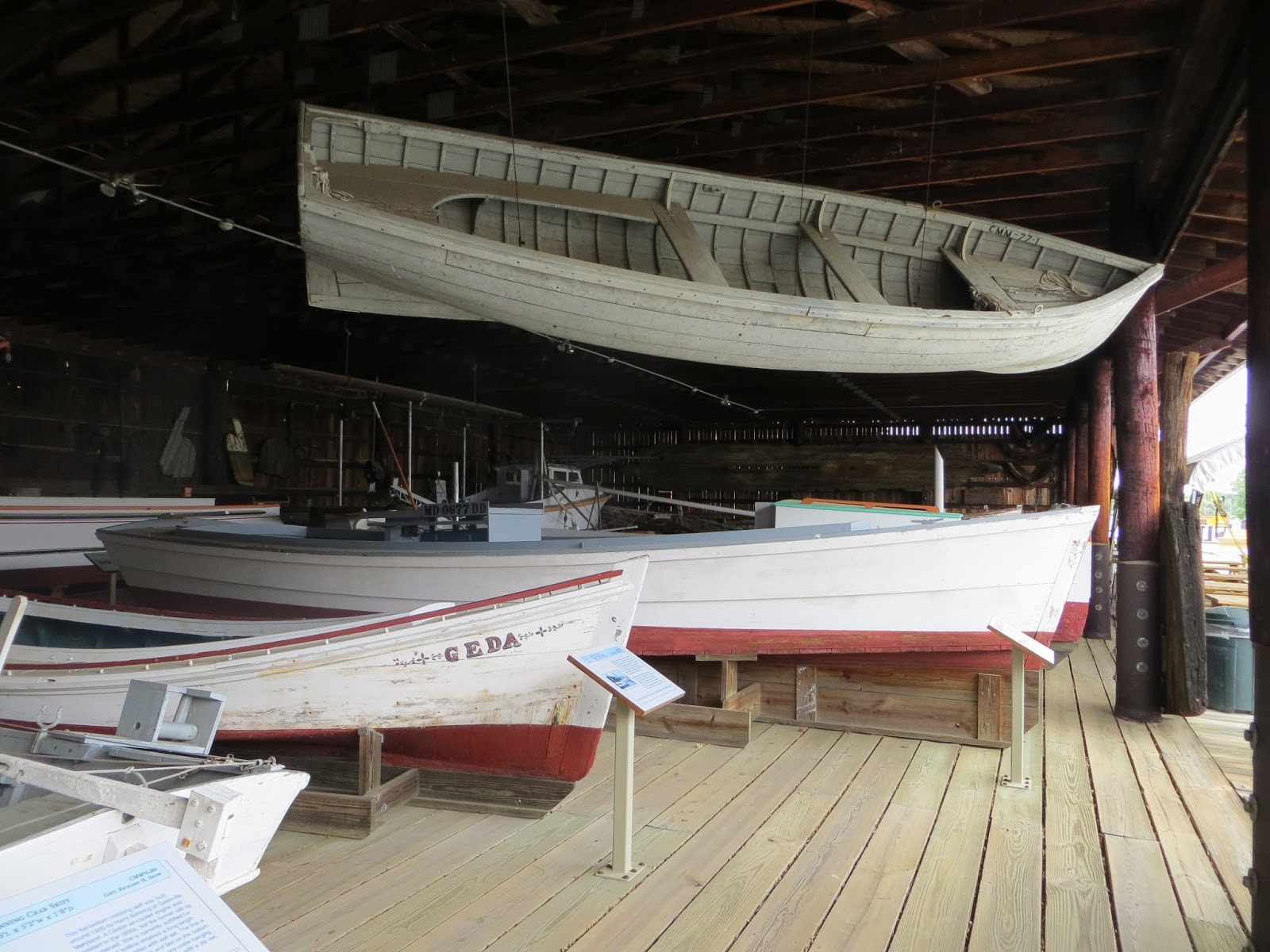


Rhonda's favorite was the Wm. B. Tennyson buyboat.


Here is the story.


The highlight of the museum was the Drum Point Lighthouse which was originally placed in operation 120 yards offshore in 1883.  It was replaced by a mechanical light and decommissioned in 1962, moved to the museum in 1975, and opened to the public in 1978 after extensive reconstruction.  Before the lighthouse was moved, the area around it completely shoaled in to the point that you could walk all the way out to it.


During the course of its 79 years of operational use, it had 19 keepers, most of whom had families living there with them until 1944 when that option ended.  Speaking of "growing up on the water" - that's literally the case for the kids of those families.  School-age children were picked up by boat to attend school.  Here are some shots of the inside.


That's a bedside potty chair in the corner in the picture above and a chamber pot at the end of the bed in the picture below. Everything went over the outside rail when you were done!


Rainwater was collected from the roof and kept in large 200-gallon drums inside the house. Collection spouts were kept closed until the rain had a chance to wash the roof - something about all of those sea gulls and roofs!


Here's the bellringer which was used during fog.  It had to be manually rewound every 2 hours and rang twice every 15 seconds.  Some of the keepers pointed out that you didn't get much sleep on those nights. 


Here's the Fresnel lens which shone as a white and red navigation light.  It was lit originally by a kerosene lamp.


Solomons and Solomons Island are pretty much lots of boats and a lot more boats, a few restaurants, a little bit of shopping, and a few pretty homes.


We finally got back to the marina and decided to borrow the courtesy car to buy some groceries.  Marina courtesy cars are an interesting story.  They are usually pretty rough and we have seen some doosies.  Probably the worst was one with a rusted-out floorboard where you could actually see the road passing by underneath you.  This one is the first Mercedes we've seen.  One of the other folks at the marina called it the "death trap."  It was actually pretty nice in my opinion with only 225,000 miles.


  It's the interiors that usually have some interesting finds and aids.  Here's a sticky label giving instructions on moving the seat.


And some duct tape that says "Do Not Touch" but it's not clear what you are not to touch.  It's a little hard to read and definitely needs a new duct tape update! We definitely appreciate the marinas that go out of their way to provide cars for boaters.


We topped the fuel tank off on the way out of Solomons - last chance to get anything close to reasonably priced fuel before continuing up the coast into NJ and NY.  We are crossing the Chesapeake Bay on this next stretch to check out the east side.  We'll be on the Choptank River and visiting "the most picturesque town on the Chesapeake" - Oxford, MD.  See you there.

Friday, May 10, 2013

Hello Maryland! Portsmouth, VA to St. Marys, MD

We finally got underway heading north up the Chesapeake Bay.  Leaving Norfolk was pretty amazing with all of the Navy vessels in port.  Here's a Naval Hospital ship, appropriately named "Comfort."


All types, including aircraft carriers.


The lighthouse at Hampton, VA on the north side of the James River.


The container ship HS Livingston from Malta was inbound from the Atlantic, clipping along at a pretty good speed and creating a pretty good wake.  There was not much room in the channel, and she put out about a 5-foot wake for us to cross.  Let's just say it rearranged the furniture in the boat!


Our friends, Don and Judy aboard "Suite Endeavor," were underway again also, heading to Reedsville, VA for the evening which would put them only one more day away from their home in Kinsale, VA.


As you proceed up the western shore of the Chesapeake Bay, there are many places to stop.  The  bay is huge and you could take years to see it all.  So, we can only pick a few as we only have a couple of weeks.  Our goal the first day was to reach Deltaville, VA, about 55 miles north from Portsmouth.  There are several  significant markers identifying shoaled areas on your port side moving northbound.  The first one is Wolf Trap Light, a 52-foot caisson (watertight retaining) structure.


As we made the turn up the Rappahannock River toward Deltaville, we passed a yellow floating buoy that was new to us.  With a little research, we found that these are part of the Chesapeake Bay Interpretive Buoy System (CBIBS), a network of observational buoys that are deployed throughout the Chesapeake to observe the estuary's changing conditions and to serve as way points along the Captain John Smith Chesapeake National Historic Trail. They are maintained by NOAA. These "smart buoys" observe and record meteorological, oceanographic, and water quality data which can be obtained in real-time by calling 1-877-BUOY-BAY or by logging on to http://buoybay.noaa.gov. Cool.


Dozier's Regatta Point is a popular stop.  The town of Deltaville is very small with a population of only 800 residents, but in the boating season it swells to thousands and several thousand boats are based there as well.  From a historical perspective, the tip end of Deltaville is Stingray Point which is commonly believed to be named from the early 17th century. According to legend, Captain John Smith was stung by a stingray there while exploring the bay. Captain Smith is said to have given orders to his men for the disposal of his body, before a cure was given to them by local Native Americans, who lived along what is now called Antipoison Creek.  We had plans to visit Stingray Point but got rained out, so we visited with two different sailboat couples most of the evening.  Here are a few pictures of Dozier's which is also known for the popular "Waterway Cruising Guides" and "Skipper Bob" books.


Dozier's had a courtesy car available so we made a trip into town for West Marine, a hardware store for a cable connection, and groceries.  We got an early start the next morning for a 58-mile run to St. Marys, MD.  At one of the widest points of the bay, about 25 miles, we began to see this huge "thing" rising up out of the horizon, the view of which is normally only about 11 miles.  It appeared to be moving quickly and headed toward us.  We were a little concerned after the huge wake we encountered the day before.  Take a look and you should understand why.  And this picture is from at least 3 miles away!


Turns out it is the "Eurasian Highway" from Japan, bound for Philadelphia and Baltimore, carrying cars and trucks, probably Toyotas!  It was built in 2012 and cruises at 16 knots.  By the time its wake got to us it was more like rolling swells so it wasn't too bad.

Now this next shot probably looks to you to be just a regular shot off the bow of our boat.  Oh no, do not be fooled by the simplicity of the photo - this is crossing the Virginia/Maryland state line as we made the turn up the mouth of the Potomac River!


There's another significant shoal marker at this point - Smith Point Lighthouse.  This huge marker is now unmanned and automatic and was sold into private hands in 2005 and was recently renovated as a 4-bedroom home!  Now that's different, huh?


About this time we see another vessel in the distance heading our way and it appears to be a huge container ship - here we go again.  You have to look closely in the far distance of the horizon.


Closer, and yes, she's big.


As it turned out, this one continued up the main channel of the bay as we continued NW-bound up the Potomac.  At it's closest point, Rhonda got this really cool picture of it that also picked up nine different vessels at varying distances on the horizon.  I love this picture, especially the small sailboat in the foreground!


The next significant marker was not nearly as interesting as the last one but is just as important, marking the shoal areas on the southern tip of Lookout Point.  It's a "skeleton" tower only.  You can still see the container ship in the distance.


We had to be careful in this area for "Fish Trap Areas and Structures."  They are designated in general areas on the charts so you have to watch out for the actual individual locations.  One possibility was heavy concentrations of crab pots.  The heaviest concentration of traps was marked with flags on both ends, easily visible if you are paying attention, but it would be easy to wander into one of these areas if you were running on autopilot and not paying attention. The other possibility was new to us - areas of stakes and nets that were easily visible, and we noted several of these along the banks of the Potomac and as we made the turn up the St. Marys River.


The water was like glass on the St. Marys River.


And for the first time in it seems like forever, we are seeing hills again.  Several homes were positioned along the banks of the river.


We spotted some folks on the shore - looks like spring is definitely here in Maryland!  Turns out these are students from St. Marys College, our destination for the afternoon.  We picked this stop for three reasons.  (1) The college has a significant boating setting. They welcome transient boaters and you can eat on campus. (2) St. Marys was the original capitol of Maryland before it was moved to Annapolis, so lots of history to see.  (3) The anchorages in the area are referred to in the cruising guides as some of the prettiest on the Chesapeake Bay.


Here's the waterfront at the college.


Here's Help Me Rhonda docked for a visit.


We had no idea that it was senior week and were not expecting quite the display of bodies (I mean seniors) basically partying in anticipation of their graduation the next day.  Rhonda encouraged me to try and discreetly get some shots (seriously, she did, and she proof-reads these blogs before I post them), so I did.  I guess this is why the guide book calls St. Marys one of the most "scenic" spots on the Chesapeake!


It took us a while to work our way to shore as we had to walk through several areas of sunbathers sprawled all over the docks.  Just part of the rigors of boating I guess but somebody has got to do it!  It was funny - when we finally got to shore we struck up a conversation with one of the students.  She said you basically have two groups here.  She pointed to the right and said "those are the drunks and I'm over here (pointing to the left) with the non-drunks."  As we observed, the "drunks" were falling in the water over and over again and the "non-drunks" seemed to be enjoying themselves utilizing all of the different types of boats available to them.


Some other students were out throwing frisbees.


The college campus was beautiful as you can see above.  Here's the entrance.


All of this, especially the emphasis on boating activities and sunbathing, kind of made me want to go back to college again.  But, then I remembered you still have to go to class, study, take tests/exams, etc. - not my forte' so probably better off just cruising the waterways in my slightly different version of "senior" years.  

Moving on to the history - in the early 1600s, two boats, The Dove and The Ark, departed England for the first planned colony of Maryland. The two ships originally sailed with 128 settlers on board ship but were brought back to England by the Royal Navy in order that the settlers might take an oath of allegiance to the King. The oath sworn, they sailed again in October 1632 for the Isle Of Wight to collect more settlers, including two Jesuit priests and almost two hundred further settlers, before sailing for Maryland.  The ships were initially separated at sea, but were reunited six weeks later at Barbados. On March the 27th they landed at what is now St. Marys, then the site of a Native American village, and they began the work of establishing a settlement there. In August 1635, the Dove sailed for England carrying timber and beaver pelts, but she never arrived home and was presumed lost in a storm.  Here's a replica of the Dove on display at St. Marys today.


St. Marys became the first capital of Maryland and they have a replica of the first state house from 1676.


There is a monument to the state house, and it is located at the original site which is now a cemetery.


There is a replica of the village area.


It's hard to believe the pillory and stocks are still standing.  (That's a joke.)


We finished the history tour and worked our way back to the boat.  The students were still at it until about 5 PM.  After the wind died down, we left the dock for our anchorage, which was in fact very nice.  It's hard to capture the setting for an anchorage with one picture, but this was the best I could do.  It was a nice pleasant and quiet evening.  


We worked our way back down the St. Marys River the next day for the Corinthian Yacht Club at Ridge, MD.  They had a Looper special going on which we decided to try.  More on that later.